With about 75% of the gold produced coming from “orogenic gold systems” (i.e. gold formed during orogenic processes and deformation), it’s not surprising we want to understand how these deposits form. One important part of Brice Lacroix’s research consists of defining the geometry of Au-deposits, and to link the mineralization to the different tectonic events that the area experienced in the past. Such an approach generally uses field investigation through structural and geological mapping coupled with cutting-edge petrography (e.g. fluid inclusion microthermometry, and geochemistry techniques).
In a recent study, Lacroix’s former student Jacob Hughes, (M.Sc. 2018) investigated the “Los Burros Au-deposit” located in the coastal ranges of the Monterey County, California. This deposit which was initially discovered in 1870, became an official mining district: the Los Burros Mining District.

The first documented mining activities within the LBMD began in 1876, where early mining activities were limited to placer mining of loose, raised gravel deposits and beach terraces. The mining activity attracted several hundred of miners, and the little remote town of Manchester was born (Figure 1). The production of modest tonnages of gold ore (~329 tons of ore from 1912 to 1914) were extracted until around 1921. The total production value from recorded LBMD ore during this time was ~$90,000 (California State Mineralogist annual report, 1916) or nearly $2.2 million when adjusted for inflation as of 2017. Although mining activities were present, which composed an important economical and historical legacy to the Monterey County, no information regarding the geology of this area was then documented. Lacroix’s working group, in collaboration with the French Geological Survey (BRGM) investigated the Los Burros deposit and its surrounding geology.
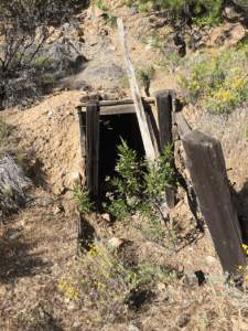
Based on geological / structural mapping, and petrographic analysis, they found that the Los Burros deposit, mining shaft, and other past mining activities (Figure 2) focused on an array of meter-wide “en-echelon” veins hosted in thick layer of Jurassic sandstone.

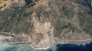
The geometry of these veins, as well as the architecture of the local geology, suggest that the Los Burros deposit formed during transpressive deformation related to the San Andreas Fault System activity, postdating the regional HP-LT metamorphism and subduction-related deformation. Transpressive deformation is generally marked by the development of topography by vertical strain resulting in crustal thickening, and uplift. Another and important product of transpressive uplift is the increasing slope angle, which could potentially trigger the formation of landslides. And guess where the last landslide occurred? Right at the investigated location, producing an important local money loss by the closure of the scenic State Road 1 since May 2017 (Figure 3). Graduate student, Christine Ward (B.Sc 2017 WSCU), is currently investigating the transpressive uplift using field-based and thermochronological approaches. Christine hopes, using this novel approach, to refine the age and the uplift rate, the amount as well as an idea about theabsolute age of the transpressive uplift and the Au-deposit. According to Lacroix, this project is really exciting because it highlights the presence of a transpressive ridge in the area of Cape San Martin area, unknown until now. In addition, even if it initially targeted the Los Burros Au-deposit formation, the results from this project also lead to better understanding of why this area is also affected by several landslides.
