KCARE Research Today

Tag: erosion

Evaluation of the geomorphological adjustment of a meandering, alluvial river

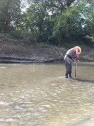
Man stands in middle of river with long pole to install scour chains in the water
K-State professor Tim Keane installs scour chains in the bed of the Cottonwood River to assess bed stability. Photo credit: Kari Bigham

This study will measure the short-term, reach-scale impacts of streambank stabilization projects on a meandering, alluvial river that outlets into a federally owned reservoir. Continue reading “Evaluation of the geomorphological adjustment of a meandering, alluvial river”

Monitoring the Effectiveness of Streambank Stabilization Projects in Northeast Kansas

Streambank stabilization projects represent a key element in the plan to reduce sediment in Kansas waterways and reservoirs. In this project, investigators worked to quantify the environmental benefits of government-sponsored streambank stabilization and restoration projects in northeastern Kansas, with a special focus on sites within the Kickapoo Tribe in Kansas and Prairie Band Potawatomi Nation Indian Reservations. Continue reading “Monitoring the Effectiveness of Streambank Stabilization Projects in Northeast Kansas”

Quantifying Ephemeral Gully Erosion and Evaluating Mitigation Strategies with Field Monitoring and Computer Modeling

Soil erosion causes severe soil degradation and significantly contributes to soil loss in agricultural fields, with some producers losing substantial amounts of arable land each season.

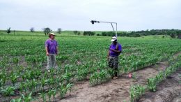
Student uses backpack camera to photograph field
Experimental cameras were used to complete measurements of ephemeral gully erosion.

To combat this soil loss, it is important to understand the mechanisms related to ephemeral gully formation and location, as well as the geomorphological properties related to storm characteristics. This three-year project works focused on these goals, as well the quantification of soil loss in Kansas resulting from ephemeral gully erosion. Continue reading “Quantifying Ephemeral Gully Erosion and Evaluating Mitigation Strategies with Field Monitoring and Computer Modeling”

Wearing down the problem: Building a model to solve ephemeral gully erosion

Student uses backpack camera to photograph field

Erosion can be a major problem for Kansas farmers: with every downpour or major weather event, precious topsoil slides away from arable fields. This eroded soil can leave large, unplantable tracts in what should be rich agricultural land. One such type of erosion yields larger rills called ephemeral gullies: they often form in the same place year after year and although they can be removed, it all adds to the farmer’s management time and cost.

Not much is known about the effectiveness of current practices for the reduction of ephemeral gully erosion. Some producers use terraces or winter cover crops to mitigate the problem. Others try creating obstacles or artificial swales to stop gully formation. It’s a time-consuming process that eats away at the farmer’s ability to focus on planting, growing, and harvesting.

That’s where Dr. Aleksey Sheshukov and his team come in. They want to assess ephemeral gully erosion by monitoring soil loss for ephemeral gullies on several no-till fields in Kansas. This will help them to evaluate the factors contributing to this type of soil loss by creating a predictive model. Once this model is complete, the team will use it to create a set of best management practices for farmers to slow ephemeral gully erosion or, better yet, keep it from happening at all.

Continue reading “Wearing down the problem: Building a model to solve ephemeral gully erosion”

Planting new foundations: Streambank stabilization on the Smoky Hill River

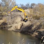
Excavator removes trees from stream bank

Streambank erosion in Kansas is a serious concern, particularly upstream of reservoirs. In just one year, normal changes in rainfall or storm events lead to tons of soil from streambanks washing away into the water, headed downstream. That same sediment, when unchecked, also can diminish reservoir capacity, degrade wetland areas, and create problems with municipal water systems.

With approval from the Corps of Engineers and funding from both the Kansas Department of Health and Environment (KDHE) and Watershed Restoration and Protections Strategies (WRAPS), watershed specialist Ron Graber and his team partnered with a select few landowners along the Smoky Hill River interested in trying an untried method of streambank stabilization. This experiment is called a “woody revetment,” and, if successful, could save landowners tens of thousands of dollars – more, if there are several unstable streambanks on a property.

Continue reading “Planting new foundations: Streambank stabilization on the Smoky Hill River”